
Theatrum Orbis Terrarum
Theatrum Orbis Terrarum (lang, "Theatre of the Lands of the World") is considered to be the first true modern atlas. Written by Abraham Ortelius, strongly encouraged by Gillis Hooftman and originally printed on 20 May 1570 in Antwerp, it consisted of a collection of uniform map sheets and supporting text bound to form a book for which copper printing plates were specifically engraved. The Ortelius atlas is sometimes referred to as the summary of sixteenth-century cartography.
Also recorded as Atlas Ortelius · Theatrvm Orbis Terrarvm · Theatre of the World
Theatrum Orbis Terrarum
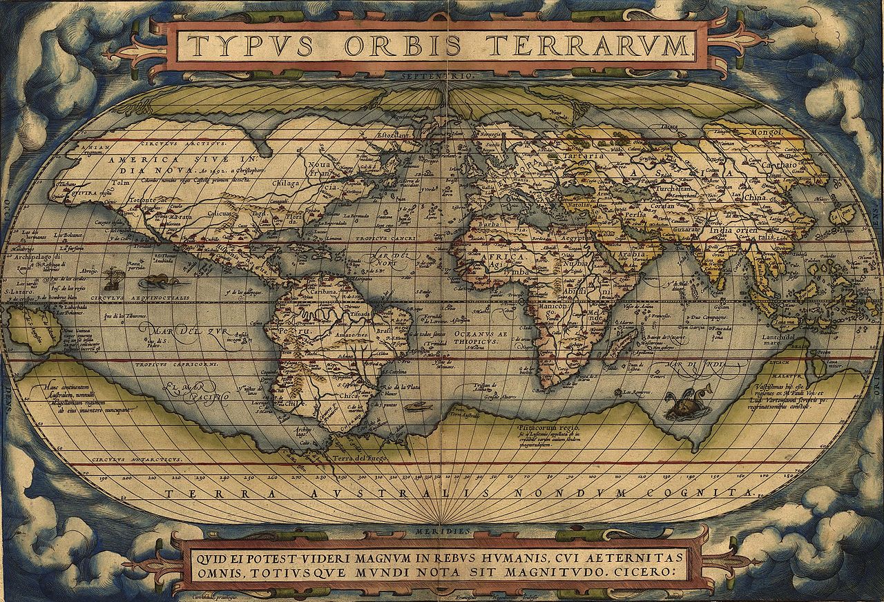
Abraham Ortelius · The Library of Congress · Public domain
- Name
- Theatrum Orbis Terrarum
- Date
- 1550
- Material
- paper · ink
VALÉORINE Encyclopedia
VALÉORINE documentary reading
Documentary summary
Theatrum Orbis Terrarum (lang, "Theatre of the Lands of the World") is considered to be the first true modern atlas. Written by Abraham Ortelius, strongly encouraged by Gillis Hooftman and originally printed on 20 May 1570 in Antwerp, it consisted of a collection of uniform map sheets and supporting text bound to form a book for which copper printing plates were specifically engraved. The Ortelius atlas is sometimes referred to as the summary of sixteenth-century cartography.
Admitted source layer · organised and presented by VALÉORINE
Note VALÉORINE
No house-authored Note is published until its assertions and sources pass the VALÉORINE evidence contract. The documentary article remains available in full while that enrichment is being consolidated.
Documentary enrichment in progress · no unsupported statement published
Reference Check
Propose documentary evidence for Theatrum Orbis Terrarum. A contribution is never written directly as fact: identity, source, rights and evidence gates still decide.
Sign in to contribute
Documentary evidence
Evidence Panel
not yet certified
- Identity
- resolved
- Independent source families
- 0
- Admitted assertions
- 0
- Open conflicts
- 0
Authority files
wikidata · Q1368633 · wikipedia · Theatrum Orbis Terrarum
In this article
The object
The object
The publication of the Theatrum Orbis Terrarum (1570) is often considered as the official beginning of the Golden Age of Netherlandish cartography (approximately 1570s–1670s).Sometimes known as the Golden Age of Dutch cartography.
Key facts
Key facts
• Name — Theatrum Orbis Terrarum • Author — Abraham Ortelius • Genre — Atlas • Publisher — Gilles Coppens de Diest
Contents
Contents
The atlas contained virtually no maps from the hand of Ortelius, but 53 bundled maps of other masters, with the source as indicated. Previously, groupings of disparate maps were only released as custom lots, to individual order. In the Ortelius atlas, however, the maps were all in the same style and of the same size, printed from copper plates, logically arranged by continent, region and state. In addition to the maps he provided a descriptive comment and referrals on the reverse. This was the first time that the entirety of Western European knowledge of the world was brought together in one book. In the bibliography, in the section 'Catalogus Auctorum', not only were the 33 cartographers mentioned whose work was recorded in the Theatrum (which at the time was not yet customary), but also the total of 87 cartographers of the 16th century that Ortelius knew. This list grew in every Latin Edition, and included no less than 183 names in 1601. Among the sources the following are mentioned: for the world map, the World Map (1561) by Giacomo Gastaldi; the porto Avenue of the Atlantic coast (1562) by Diego Gutierrez, the world map (1569) of Gerardus Mercator, which have eight maps derived from the Theatrum. For the map of Europe, wall map (1554). of the Mercator map of Scandinavia (1539) by Olaus Magnus, map of Asia was derived from his own Asia-map from 1567, which in turn was inspired by that of Gastaldi (1559). Also for the Africa map he referred to Gastaldi. This work by Ortelius, consisted of a collection of the best maps, refined by himself, combined into one map or split across multiple, and on the same size (folios of approximately 35 x 50 cm). The naming and location coordinates were not normalized.
Structure
Structure
• Illustration — Title page from a 1606 edition with female figures representing the continents All the editions had the same structure. They started with an allegorical title page, on which the five known continents were presented by allegorical women, with Europe as the Queen. Then a reference to Philip II, King of Spain and the Low Countries, and a poem by Adolphus Mekerchus (Adolf of Meetkercke). From 1579, the editions contain a portrait of Ortelius by Philip Galle, an introduction by Ortelius, in the Latin editions followed by a recommendation by Mercator. This is followed by the bibliography (Catalogus Auctorum), an index (Index Tabularum), the maps with text on the back, followed (starting from 1579 in the Latin editions) by a register of place names in ancient times (Nomenclator), the treatise, the Mona Druidum insula of the Welsh scientist Humphrey Lhuyd (Humphrey Llwyd) over the Anglesey coat of arms, and finally the 'privilege' and a colophon.
Cost
Cost
The moneyed middle class, which had much interest in knowledge and science, turned out to be very much interested in the convenient size and the pooling of knowledge. For buyers who were not strong in Latin, from the end of 1572, in addition to the Latin version, Dutch, German and French editions were published. This rapid success prompted the Ortelius Theatrum to constantly expand and improve. In 1573, he released 17 more additional maps under the title Additamentum Theatri Orbis Terrarum, bringing the total at 70 maps. By Ortelius' death in 1598, there were twenty-five editions that had appeared in seven different languages.
Image gallery
Image gallery
• Illustration — Africa and the Arabian Peninsula • Illustration — Turkish Empire • Illustration — Russia and Tartary • Illustration — China and South East Asia, with West at the top • Illustration — Maris Pacifici including Terra Australis • Illustration — Poland and Lithuania • Illustration — Hibernia
History of the object
Dated record
History of the object
Explore 1550–1974
The full dated record · 4 entries
1550
Theatrum Orbis Terrarum created.
1550
Theatrum Orbis Terrarum is recorded from 1550.
1570
Theatrum Orbis Terrarum published.
1974
Theatrum orbis terrarum--corpus of old atlases in facsimile. (1974) is digitised and catalogued by Internet Archive.
Editions
After the initial publication of Theatrum Orbis Terrarum, Ortelius regularly revised and expanded the atlas, reissuing it in various formats until his death in 1598. From its original seventy maps and eighty-seven bibliographic references in the first edition (1570), the atlas grew through its thirty-one editions to encompass 183 references and 167 maps in 1612. The online copy of the 1573 volume held by the State Library of New South Wales contains 70 numbered double-page sheets, tipped onto stubs at the centerfold, with six maps combined with descriptive letterpress on the recto of each first leaf. The legends of most maps name the author whose map Ortelius adapted. In the preface Ortelius credits Franciscus Hogenberg with engraving nearly all the maps. The 1573 Additamentum to the atlas is notable for containing Humphrey Llwyd's Cambriae Typus, the first map to show Wales on its own. Theatrum Orbis Terrarum is used as the centerpiece of the Fool's Cap Map of the World, which is a satirical presentation of Europe's understanding of the globe. From the 1630s, the Blaeu family issued their work under a similar title, Theatrum orbis terrarum, sive, Atlas Novus.
Citations
References
Each reference names the institution holding it, so a reader may go to the document itself.
reference work
Partially resolvedreference work
Partially resolved
The Encyclopedia exists whether or not anything is for sale. Corrections are recorded rather than overwritten, and every version of this record is kept. Published 14 August 2026.
Elsewhere in Maps and atlases
1,180 published records in this field, each with its sources named.
- Teofil ŻebrawskiAuthor
- Terence ArmstrongAuthor
- Thaddäus HaenkeAuthor
- Thaddeus Mortimer FowlerAuthor
- Therkel MathiassenAuthor
- Thomas BaskerfieldAuthor
- Thomas BowenAuthor
- Thomas BuggeAuthor
Best supported in this field
For owners
Own a copy of Theatrum Orbis Terrarum?
A specialist will read what you send and tell you what the house can establish, what it cannot, and whether the object is suited to sale. There is no charge and no obligation. The object stays with you throughout; nothing is shipped to us unless it is arranged in writing beforehand.