
Jean Baptiste Bourguignon d'Anville
Jean-Baptiste Bourguignon d'Anville (French pronunciation: [ʒɑ̃ batist buʁgiɲɔ̃ dɑ̃vil]; born in Paris 11 July 1697 – 28 January 1782) was a French geographer and cartographer who greatly improved the standards of map-making. D'Anville became cartographer to the king, who purchased his cartographic materials, the largest collection in France. He made more than 200 maps during his lifetime, which are characterized by a careful, accurate work largely based on original research.
Jean Baptiste Bourguignon d'Anville
![Sujet: Chorographie Cartouches (ornement) Théâtre de la guerre Italie -- Nord-Ouest Milan, Duché de -- Ouest Ligurie, Région Piémont, Principauté du Échelle(s): [1:236 500 environ]](https://upload.wikimedia.org/wikipedia/commons/thumb/9/9d/Nouvelle_Carte_de_la_Lombardie%2C_ou_Th%C3%A9%C3%A2tre_de_la_Guerre_en_Italie%2C_Comprenant_le_Pi%C3%A9mont%2C_la_R%C3%A9publique_de_G%C3%AAnes_et_Partie_de_la_Savoie._Dress%C3%A9e_sur_les_meilleurs_Cartes_Nationales_et_sur_des_Manuscrits_fort_ex..._-_btv1b530997429.jpg/1280px-Nouvelle_Carte_de_la_Lombardie%2C_ou_Th%C3%A9%C3%A2tre_de_la_Guerre_en_Italie%2C_Comprenant_le_Pi%C3%A9mont%2C_la_R%C3%A9publique_de_G%C3%AAnes_et_Partie_de_la_Savoie._Dress%C3%A9e_sur_les_meilleurs_Cartes_Nationales_et_sur_des_Manuscrits_fort_ex..._-_btv1b530997429.jpg)
Buache, Philippe (1700-1773). Éditeur scientifique Dezauche, Jean-Claude (1745?-1824). Éditeur scientifique Anville, Jean-Baptiste Bourguignon d' (1697-1782). Auteur du texte · Bibliothèque nationale de France · Public domain
- Born
- 1697.
- Died
- 1782.
- Nationality
- France.
- Occupation
- cartographer, geographer, encyclopédistes, independent publisher and secretary.
VALÉORINE Encyclopedia
VALÉORINE documentary reading
Documentary summary
Jean-Baptiste Bourguignon d'Anville (French pronunciation: [ʒɑ̃ batist buʁgiɲɔ̃ dɑ̃vil]; born in Paris 11 July 1697 – 28 January 1782) was a French geographer and cartographer who greatly improved the standards of map-making. D'Anville became cartographer to the king, who purchased his cartographic materials, the largest collection in France. He made more than 200 maps during his lifetime, which are characterized by a careful, accurate work largely based on original research.
Admitted source layer · organised and presented by VALÉORINE
Note VALÉORINE
No house-authored Note is published until its assertions and sources pass the VALÉORINE evidence contract. The documentary article remains available in full while that enrichment is being consolidated.
Documentary enrichment in progress · no unsupported statement published
Reference Check
Propose documentary evidence for Jean Baptiste Bourguignon d'Anville. A contribution is never written directly as fact: identity, source, rights and evidence gates still decide.
Sign in to contribute
World of VALÉORINE
Documentary connections
Only confirmed graph relationships appear here. Images are shown only when their identity and reuse rights both pass the documentary gate.

Documentary evidence
Evidence Panel
wikipedia incomplete · checked 25 September 2026
- Identity
- resolved
- Independent source families
- 0
- Admitted assertions
- 0
- Open conflicts
- 0
Authority files
wikidata · Q733907 · wikipedia · Jean-Baptiste Bourguignon d'Anville
In this article
Biography
In particular, D'Anville left unknown areas of continents blank and noted doubtful information as such, contrary to the lavish maps of his predecessors. His maps remained the reference point in cartography throughout the 19th century and were used by numerous explorers and travellers.
Jean-Baptiste Bourguignon d'Anville was born in Paris on 11 July 1697, in the Kingdom of France. His passion for geographical research displayed itself from early years: aged twelve he was already amusing himself by drawing maps for Latin authors. Later, his friendship with the antiquarian, Abbé Longuerue, greatly aided his studies. His first serious map, that of Ancient Greece, was published when he was fifteen. At the age of twenty-two, he was appointed one the king's geographers, and began to attract the attention of first authorities. D'Anville's studies embraced everything of geographical nature in the world's literature, as far as he could muster it: for this purpose, he not only searched ancient and modern historians, travelers and narrators of every description, but also poets, orators and philosophers. One of his cherished subjects was to reform geography by putting an end to the blind copying of older maps, by testing the commonly accepted positions of places through a rigorous examination of all the descriptive authority, and by excluding from cartography every name inadequately supported. Vast spaces, which had before been bordered with countries and cities, were thus suddenly reduced mostly to a blank. D'Anville was at first employed in the humbler task of illustrating by maps the works of different travellers, such as Marchais, Charlevoix, Labat and du Halde. For the description of China by the last-named writer he was employed to make an atlas, which was published separately at the Hague in 1737. Information for the maps of China came from land surveys made across the Chinese empire by the order of the Kangxi Emperor from 1708–1716. D'Anville's China maps were called the "standard Western source for the geography of China and adjacent regions," throughout the 19th century. In 1735 and 1736, he brought out two treatises on the figure of the earth; but these attempts to solve geometrical problems by literary material were, to a great extent, refuted by Maupertuis' measurements of a degree within the polar circle. D'Anville's historical method was more successful in his 1743 map of Italy, which first indicated numerous errors in the mapping of that country and was accompanied by a valuable mémoir (a novelty in such work), showing in full the sources of the design. A trigonometrical survey which Benedict XIV soon after had made in the papal states strikingly confirmed the French geographer's results. In his later years d'Anville did yeoman service for ancient and medieval geography, accomplishing something like a revolution in the former; mapping afresh all the chief countries of the pre-Christian civilizations (especially Egypt), and by his Mémoire et abrégé de géographie ancienne et générale and his États formés en Europe après la chute de l'empire romain en occident (1771) rendering his labours still more generally useful. His last employment consisted in arranging his collection of maps, plans and geographical materials. It was the most extensive in Europe, and had been purchased by the king, who, however, left him the use of it during his life. This task performed, he sank into a total imbecility both of mind and body, which continued for two years, until his death in January 1782.
Primary material
Documents and archives
authority record
- Wikidata, structured authority record Q733907: Jean Baptiste Bourguignon d'Anville
Unverified · Wikidata
reference work
- “Jean-Baptiste Bourguignon d'Anville”, English Wikipedia, consulted as further reading
Reputable secondary · Wikipedia
Honors
In 1754, at the age of fifty-seven, he became a member of the Académie des Inscriptions et Belles Lettres, whose transactions he enriched with many papers. In 1773, he became adjoint géographe of the Académie des Sciences, and in the same year was appointed first geographer to the king. He was also a member of the Society of Antiquaries of London and the Russian Academy of Sciences. A street was named after him 82 years after his death in the 14th arrondissement of Paris, and his statue was placed on the city's Hotel de Ville in 1881. The crater Anville on the Moon and the community of Danville, Vermont are also named after him.
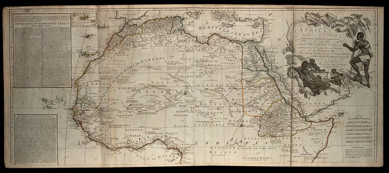
Map of Northern Africa; African people in a rococo frame on the upper right hand of the map. Coloured engraving, 1772., 1st August 1772, by Jean Baptiste Bourguignon d'Anville
Jean Baptiste Bourguignon d'Anville · Wellcome Collection, London · Wellcome Collection
Notes from the source article
Cited by Wikipedia
Notes from the source article
These works are cited by the source article, in its own numbering. They are recorded as its citations, not as sources VALÉORINE has verified.
- 1.Columbia University Press. The Columbia Encyclopedia. 2012.
- 2.Edney, Matthew H. The History of Cartography, Volume 4: Cartography in the European Enlightenment. University of Chicago Press. 114–115. 2020. 978-0-226-33922-1.
- 3.gpn 307
- 4.Gannett, Henry. The Origin of Certain Place Names in the United States. Government Printing Office. 100. 1905.
- 5.World Digital Library. New Atlas of China, Chinese Tartary and Tibet.
Bibliography printed in the source article · 4
- Pere J. B. du Halde with maps by d'Anville, "Description geographique de la Chine", 1735.
- World Digital Library. New Atlas of China, Chinese Tartary and Tibet.
- "Atlas General", circa 1740.
- "Geographie Ancienne et Abregee", 1769.
References
Citations
References
Each reference names the institution holding it, so a reader may go to the document itself.
authority record
Partially resolvedreference work
Partially resolved
People, houses and institutions
Knowledge graph
People, houses and institutions
Teachers, collaborators, publishers and institutions recorded against this person, each on a stated basis.
The Encyclopedia exists whether or not anything is for sale. Corrections are recorded rather than overwritten, and every version of this record is kept. Published 14 August 2026.
Elsewhere in Maps and atlases
1,180 published records in this field, each with its sources named.
- Jan TyssowskiAuthor
- Jan Van HanswijkAuthor
- Jay GouldAuthor
- Jean Baptiste BerthierAuthor
- Jean BourdonAuthor
- Jean de BeaurainAuthor
- Jean de ClamorganAuthor
- Jean de ThévenotAuthor
Best supported in this field
For owners
Own a work by Jean Baptiste Bourguignon d'Anville?
A specialist will read what you send and tell you what the house can establish, what it cannot, and whether the object is suited to sale. There is no charge and no obligation. The object stays with you throughout; nothing is shipped to us unless it is arranged in writing beforehand.