
Christophe Tassin
Christophe Tassin (born in the early 1600s in France; died in 1660 in France), also known as Nicolas Tassin, Christophe Nicolas Tassin or Christophe Le Tassin, was a French cartographer, known for his atlases of France, Spain, Germany and Switzerland. Most of his work was published in Paris from 1633 to 1635. Among his colleagues were Melchior Tavernier (1594–1665), Sébastien Cramoisy (1584–1669) and Michael van Lochum (1601–1647).
Also recorded as Nicolas Tasin · Nicolas Tassin
Christophe Tassin

Christophe Tassin · Neptunia n°263, septembre 2011 · Public domain
- Died
- 1660 · France.
- Nationality
- France
- Occupation
- architect · cartographer
- Languages
- French
VALÉORINE Encyclopedia
VALÉORINE documentary reading
Documentary summary
Christophe Tassin (born in the early 1600s in France; died in 1660 in France), also known as Nicolas Tassin, Christophe Nicolas Tassin or Christophe Le Tassin, was a French cartographer, known for his atlases of France, Spain, Germany and Switzerland. Most of his work was published in Paris from 1633 to 1635. Among his colleagues were Melchior Tavernier (1594–1665), Sébastien Cramoisy (1584–1669) and Michael van Lochum (1601–1647).
Admitted source layer · organised and presented by VALÉORINE
Reference Check
Propose documentary evidence for Christophe Tassin. A contribution is never written directly as fact: identity, source, rights and evidence gates still decide.
Sign in to contribute
World of VALÉORINE
Documentary connections
Only confirmed graph relationships appear here. Images are shown only when their identity and reuse rights both pass the documentary gate.
Documentary evidence
Documentary basis
Authority files
wikidata · Q17310814 · wikipedia · Christophe Tassin
In this article
Career
Career
Little is known of his personal life.
Up to 1631 Christophe Tassin was a French Royal Engineer and Geographer (Ingenieur et Geographe du Roy), working on assigned political and military projects. As part of his appointment, he received the right to publish his work for ten years, though he used it only between 1633 and 1638. (His successor as Royal Engineer and Geographer and publisher was Sébastien de Beaulieu [1612–1674].) In 1633 Tassin published an atlas of France and Spain, Cartes générales des provinces de France et d’ Espagne; one of Germany, Cartes généralis des royaumes et provinces de la haute et basse Allemagna; and one of the Low Countries, Plans et profils des principales villes du duché de Lorraine, avec les cartes generale et particulieres de chacun gouvernement d’iucelles. • Illustration — View of Amiens in 1634 In 1634 he published his magnum opus, an atlas – in an oblong quarto format, for which he is best known – with maps, views and plans of cities and other places in France, Les plans et profils de toutes les principales villes et lieux considerables de France, as well as a coastal atlas of France, Carte générale de toutes les costes de France. In 1635 he published an atlas of Switzerland, Description de tovs les cantons, villes, bourgs, villages et av tres particularitzes du pays des Suisses. His inclusion of the Low Countries in a single volume had a practical reason: in 1631 a great part of the region had been conquered by King Louis XIII, which caused a need for rapidly published information. In 1644 Tassin ended his work, and sold his copper plates of maps to Antoine de Fer (16xx–1673), who published them in many subsequent editions.

Christophe Tassin, Brouage-IMG 7010
Christophe Tassin · Neptunia n°263, septembre 2011
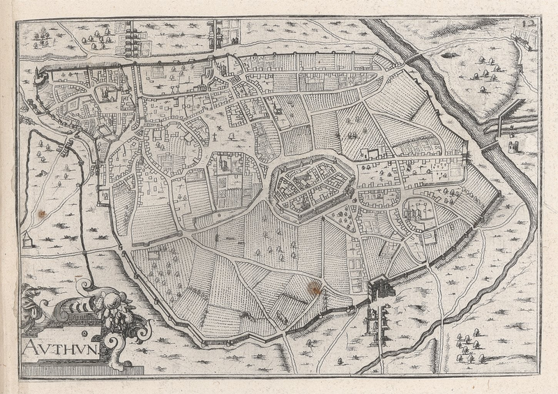
Carte d'"Authun" (Autun, Saône-et-Loire). Issue de Plans de villes de Bourgogne, 1634. 10,5 x 15 cm
Christophe Tassin
Life and career
Dated record
Life and career
The full dated record · 2 entries
1650
Christophe Tassin born at Dijon.
1660
Christophe Tassin died at France.
Places
Named by the record
Places
Only places the record itself states, plotted where the house gazetteer settles their coordinates. Nothing is inferred from a name or a nationality.
Dijon.
Birth place
France.
Death place
Notes from the source article
Cited by Wikipedia
Notes from the source article
These works are cited by the source article, in its own numbering. They are recorded as its citations, not as sources VALÉORINE has verified.
- 1.Tassin.
Bibliography printed in the source article · 2
- Reiniger, Wolfgang. Beaulieu: Die Kupferstiche zu den Feldzügen Ludwig XIV., insbesondere zu denen in Deutschland: Katalog. W. Reiniger. 2000. 9783923714063.
- Hellwig, Fritz. Landkarten der Pfalz am Rhein 1513–1803: Katalog der gedruckten Karten mit einer kartenhistorischen Einführung. W. Reiniger. 1984. 9783923714018.
References
Citations
References
Each reference names the institution holding it, so a reader may go to the document itself.
reference work
Secondary witnessreference work
Secondary witness
Further particulars
Held on the record
Further particulars
Open the remaining particulars
A count of publications is evidence of attention, not of standing, and is given here only as a measure.
The Encyclopedia exists whether or not anything is for sale. Corrections are recorded rather than overwritten, and every version of this record is kept. Published 16 August 2026.
Elsewhere in Maps and atlases
1,180 published records in this field, each with its sources named.
- Christian Gottlieb ReichardAuthor
- Christian MayerAuthor
- Christian Tuxen FalbeAuthor
- Christie WillattsAuthor
- Christopher BoardAuthor
- Christopher Dufrost de La JemerayeAuthor
- Christopher GreenwoodAuthor
- Christopher SaxtonAuthor
Best supported in this field
For owners
Own a work by Christophe Tassin?
A specialist will read what you send and tell you what the house can establish, what it cannot, and whether the object is suited to sale. There is no charge and no obligation. The object stays with you throughout; nothing is shipped to us unless it is arranged in writing beforehand.