
Cherukunnu
Cherukunnu is a census town in Kannur district in the Indian state of Kerala. It is located on the Pappinisseri-Pilathara KSTP road, about 16 km northwest of the district headquarters Kannur and 6.5 km southeast of Pazhayangadi.
Cherukunnu
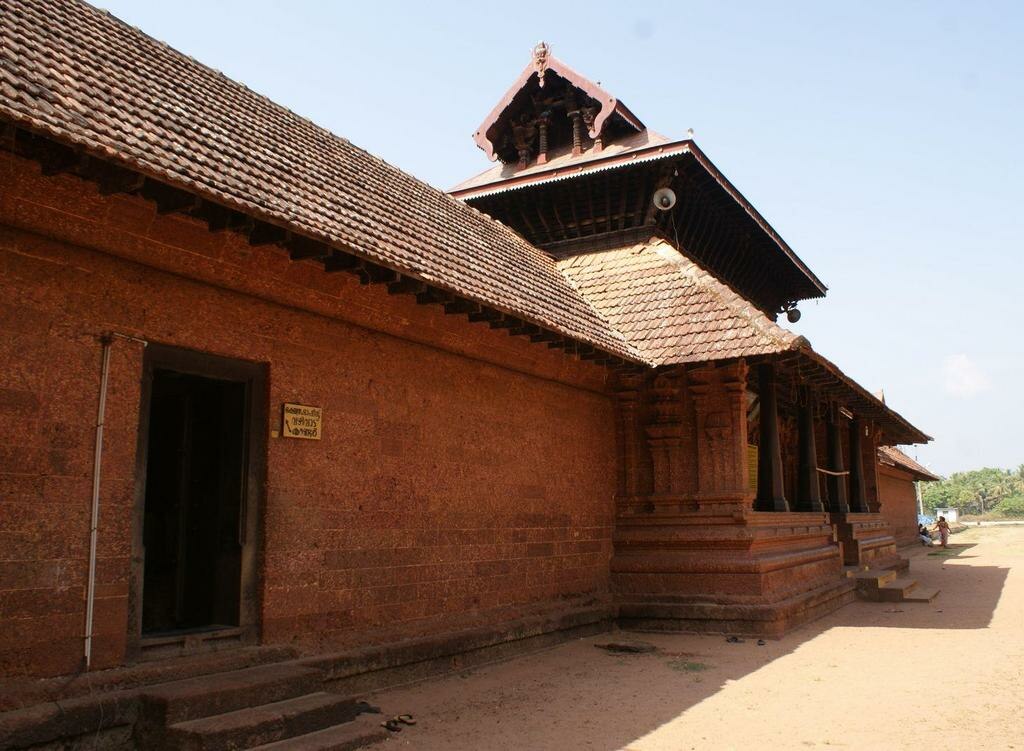
prakashkpc. Prakashkpc at en.wikipedia · Public domain
- Name
- Cherukunnu
Reference Check
Propose documentary evidence for Cherukunnu. A contribution is never written directly as fact: identity, source, rights and evidence gates still decide.
Sign in to contribute
World of VALÉORINE
Documentary connections
Only confirmed graph relationships appear here. Images are shown only when their identity and reuse rights both pass the documentary gate.

In this article
Key facts
Key facts
• Name — Cherukunnu • Type — Census Town • Subdivision Type — Country • Subdivision Name — India • Subdivision Type1 — State • Subdivision Name1 — Kerala • Subdivision Type2 — District • Subdivision Name2 — Kannur • Parts Type — Taluk • Parts — Kannur • Governing Body — Panchayat (First Grade) • Unit Pref — Metric • Area Total Km2 — 15.37 • Population Total — 16,111 • Population As Of — 2011 • Population Density Km2 — auto • Demographics Type1 — Languages • Demographics1 Title1 — Official • Demographics1 Info1 — Malayalam, English • Time Zone1 — IST • Utc Offset1 — +5:30 • Postal Code Type — PIN • Postal Code — 670301 • Area Code Type — Telephone code • Area Code — 0497 • Registration Plate — KL-13 • Custom Label1 Sec1 — Sex ratio • Custom Data1 Sec1 — 1252 ♂/♀ • Custom Label2 Sec1 — Literacy • Custom Data2 Sec1 — 95.4% • Custom Label3 Sec1 — Lok Sabha constituency • Custom Data3 Sec1 — Kasaragode • Custom Label4 Sec1 — Vidhan Sabha constituency • Custom Data4 Sec1 — Kalliasseri • Custom Label5 Sec1 — Civic agency • Custom Data5 Sec1 — Panchayat (First Grade) • Custom Label1 Sec2 — Climate • Custom Data1 Sec2 — pleasant (Köppen) • Iso Code — IN-KL • Illustration — Annapoorneshwari Temple • Illustration — Paddy fields
Demographics
Demographics
As of 2011 Census, Cherukunnu had a population of 16,111 which constitutes 7,153 (44.4%) males and 8,958 (55.6%) females. Cherukunnu census town spreads over an area of 15.33 km 2 with 3,418 families residing in it. The sex ratio of Cherukunnu was 1,252, higher than the state average of 1,084. In Cherukunnu, 11.8% of the population is under 6 years of age. Cherukunnu had an overall literacy of 95.4%, higher than the state average of 94%. The male literacy stands at 97.8% and female literacy at 93.5%.
Religions
Religions
As of 2011 census, Cherukunnu census town had total population of 16,111 among which 8,984 (55.8%) are Hindus, 5,648 (35%) are Muslims, 1,448 (9%) are Christians and 0.2% others.
Culture and geography
Culture and geography
Greater part of this village is surrounded by Backwater. The thuruths (small islands) of "Ayiram Thengau" and "Mungam" are places of interest nearby. This village shares borders with Kannapuram to the south, Madayi to the north, Mattool to the west, Ezhome and Pattuvam to the east. Cherukunnu is famous for: • Thavam Roman Catholic church; • Oliyankara Juma Masjid; • Annapoorneswari Temple; • Mission Hospital.
Thavam Church
Thavam Church
• Illustration — Thavam Church The Thavam Church is a Roman Catholic Church in North Malabar. This church is very old, which proclaims the presence of Christians in North Malabar since ancient days. This is a heritage place for North Malabar Roman Catholic society. This church is under the Diocese of Kannur. This church is located at Thavam, between Cherukunnu and Pazhayangadi, around 17 km from Kannur, 19 km from Taliparamba and 15 km from Payyannur. Pazhayangadi is the nearest railway station. Other Roman Catholic churches in the Cherukunnu area include those at Kattakulam, Paadiyil Ferry, and Kavinisseri (Christhukunnu).
Oliyankara Juma Masjid
Oliyankara Juma Masjid
Oliyankara Juma Masjid (Valiyullahi), a Famous Dargah Shareef of Sahaba-e-Ikhram (Sufi Saints/Auliyas) is an important Mosque of North Malabar. It is believed that the priests in ancient days gave importance to the Hindu Gods at this Mosque. The Mosque is at Pallichal near Cherukunnu town, around 14 km from Kannur, 16 km from Taliparamba and 18 km from Payyannur. This is a location of a sufi grave, visited by people of all religions. Kannapuram is the nearest rail head.
Annapoorneshwari Temple
Annapoorneshwari Temple
At this Temple, Krishna is collocated with Sree Annapoorneswari. It is believed that Sree Annapoorneswari has visited this shrine which was under the sea. There is a mythological belief that this shrine was elevated by Parashurama. The temple is near Cherukunnu town, around 14 km from Kannur, 16 km from Taliparamba and 18 km from Payyannur. A large chira (swimming pool) also can be spotted near this temple. In April every year, various religious and ritual and entertainment activities, including spectacle fireworks, are shown at this Temple to during the celebration of Vishu Villakulsavam. Kannapuram is the nearest rail head.
Mission Hospital
Mission Hospital
Mission Hospital alias St. Martin de Porres Hospital Cherukunnu is a well-known hospital of this region. The hospital is equipped with modern medical facilities and also has a 24-hour Casualty and Trauma Care Centre. The Leprosy Department of this hospital provides free of cost treatment to Leprosy patients. This hospital is attached with a Nursing College viz. "Canossian College of Nursing" run by "Canossian Daughters of Charity" Convent Cherukunnu.
Politics
Politics
After re-constituting; Cherukunnu is under Kalliasseri Assembly constituency which is part of Kasaragod Lok Sabha constituency. Earlier, this place was under Azhikode Assembly constituency of Kannur Lok Sabha constituency. As of 2026, the following persons represents this village on behalf of its people. • M.L.A.]] — Mr. M. Vijin — M.P. — Rajmohan Unnithan]]
Transportation
Transportation
The National Highway 66 passes through Taliparamba town. Goa and Mumbai can be accessed on the northern side and Cochin and Thiruvananthapuram can be accessed on the southern side. Cherukunnu town is located on Valapattanam-Pappinisseri-Pazhayangadi main road which gets connected to the NH-66 through Pilathara at the north and Valapattanam bridge at the south. The nearest railway stations are Kannapuram and Pazhayangadi, located 1 km to the south and 7.5 km to the north of Cherukunnu respectively. The nearest major railhead is Kannur, located 16.5 km to the south on the Shoranur-Mangalore section of the Southern Railway zone. Trains are available to almost all parts of India subject to advance booking over the internet. There are airports at Kannur, Mangalore and Calicut. All of them are international airports but direct flights are available only to Middle Eastern countries.
Text attribution
Licensing
Text attribution
Part of the biographical narrative on this page reuses licensed material. Its origin, revision and licence are recorded here.
The biographical narrative on this page is based on the Wikipedia article Cherukunnu, revision 1376706907 (EN edition), by its contributors. VALÉORINE has edited that text and built its own documentary record around it. The reused material is available under CC BY-SA 4.0, and this page's reuse of it is offered under the same licence. Everything else on this page — the chronology, the holdings, the evidence, the plates and the connections — is VALÉORINE's own record. Sources and licences.
Notes from the source article
Cited by Wikipedia
Notes from the source article
These works are cited by the source article, in its own numbering. They are recorded as its citations, not as sources VALÉORINE has verified.
- 1.Kerala (India): Districts, Cities and Towns - Population Statistics, Charts and Map.
- 2.Registrar General & Census Commissioner, India. Census of India : Villages with population 5000 & above.
- 3.Kannur.gov.in : Villages of Kannur District.
- 4.Cherukunnu (i), Cherukunnu (i) Panchayat, Kannur District, Kerala, India. Kerala Tourism.
- 5.Express News Service. Malayali soldier falls into gorge in Poonch, dies. The New Indian Express. 2025-11-23.
- 6.Kerala, Directorate of Census Operations. District Census Handbook, Kannur. Directorate of Census Operations, Kerala. 186,187.
- 7.Office of the Registrar General. Religion – Kerala, Districts and Sub-districts. Census of India 2011.
- 8.Kannur District Map : Villages of Kannur.
- 9.Diocese of Kannur : Organisation Structure.
- 10.Aulia-e-hind : List of Daragahs in Kerala.
- 11.Kerala Tourism : Tourist places of Cherukunnu.
- 12.Temples of Kerala : List of Famous Hindu Temples in Kerala.
- 13.India9 : Temples in India.
- 14.Healthy Family Happy Family : Human Anatomy Study.
- 15.SMDP Hospital : College of Nursing.
- 16.Study Nation : Colleges in India.
- 17.Election Commission of India. Assembly Constituencies - Corresponding Districts and Parliamentary Constituencies. Kerala.
Makers, houses and production
Knowledge graph
Makers, houses and production
The people, houses and objects recorded in connection with this place.
Died at
1- Kallen PokkudanAuthor
Established from a fact already recorded on a verified source.
The Encyclopedia exists whether or not anything is for sale. Corrections are recorded rather than overwritten, and every version of this record is kept. Published 27 September 2026.
Elsewhere in General
22,760 published records in this field, each with its sources named.
- CherryvalePlace
- ChersonesusPlace
- CherthalaPlace
- ChertseyPlace
- Cherven bryagPlace
- Chesapeake CityPlace
- Chesham BoisPlace
- CheshirePlace
Best supported in this field
For owners
Own an object connected with Cherukunnu?
A specialist will read what you send and tell you what the house can establish, what it cannot, and whether the object is suited to sale. There is no charge and no obligation. The object stays with you throughout; nothing is shipped to us unless it is arranged in writing beforehand.