
Joris Carolus
Joris Carolus (c. 1636) was a Dutch cartographer and explorer who was employed by the Noordsche Compagnie and the Dutch East India Company.
Joris Carolus
Joris Carolus · Nationaal Archief, Den Haag, Archieven van de Compagnieën op Oost-Indië 1.04.01 inventorynumber 136 · Public domain
- Born
- 1566 · Enkhuizen.
- Died
- 1636 · Amsterdam.
- Occupation
- explorer · cartographer · draftsperson · navigator · sick comforter · skipper
- Languages
- Dutch
VALÉORINE Encyclopedia
VALÉORINE documentary reading
Documentary summary
Joris Carolus (c. 1636) was a Dutch cartographer and explorer who was employed by the Noordsche Compagnie and the Dutch East India Company.
Admitted source layer · organised and presented by VALÉORINE
Reference Check
Propose documentary evidence for Joris Carolus. A contribution is never written directly as fact: identity, source, rights and evidence gates still decide.
Sign in to contribute
Documentary evidence
Documentary basis
Authority files
wikidata · Q6278875 · wikipedia · Joris Carolus
In this article
Early life and background
Early life and background
Joris Carolus was born in the Dutch Republic, probably in or near Enkhuizen, in the late 16th century. Little is known about his early life or training, though later records describe him as a skilled pilot, cartographer, and teacher of navigation.
Career
Career
Before becoming an Arctic navigator and cartographer, Carolus served as a soldier during the Eighty Years' War. During the Siege of Ostend (1601–1604) he lost a leg, an injury that appears to have ended his time as a soldier and led him toward navigation and mapmaking. In 1614 Carolus served as pilot aboard the Enkhuizen vessel den Orangienboom ("Orange Tree"), which was sent north by the Noordsche Compagnie during a Dutch Arctic expedition linked to whaling and exploration. The expedition sailed to Spitsbergen, where he took part in mapping of the Arctic region. Carolus claimed to have reached 83° N, but this would have been impossible given the ice conditions described by Robert Fotherby, who was also on a voyage of discovery in the ship Thomasine, sent by the rival Muscovy Company of England. According to Fotherby—who saw the Dutch ships riding off Amsterdam Island on July 6/16, "ready for the first opportunity to discover", and on August 9/19 "two ships of the Hollanders, that were appointed for northern discovery, were seene thwart of Faire Haven, sayling to the southwards"— the ice was packed along the northern coast of Spitsbergen. Even in shallops the English were only able to go as far north as Castlins Point (modern Gråhuken, at 79° 48’N). On the same voyage Carolus came upon the island of Jan Mayen, which may have been discovered earlier the same year by the Dutchman Fopp Gerritsz., sailing in a whaleship sent by the Englishman John Clarke, of Dunkirk. Carolus named it after himself: Mr. Joris eylandt. He also named a bay Gowenaers bay (which name was moved to Gouwenaerbåen) after the master of his ship, and a cape Jan Meys hoeck. This latter name, in honor of Jan Jacobsz. May, master of the other ship sent on discovery, de goude Cath (“The Golden Cat”) of Amsterdam, was later (1620) applied to the island as a whole, giving it the name it retains to this day. Following his 1614 expedition to Spitsbergen Carolus charted a map of the islands. The map labels various features, including Generaels hoeck (South Cape), Bell sound (Bellsund), Greene harbergh (Grønfjorden), Mari mag. bay (Magdalenefjorden), Hollandsche bay or Feer-haven (Fairhaven), and de Reus ("The Giant", Cloven Cliff), among other things. The map also shows what may be Edge Island’s south coast. Carolus showed the coastline split into two parts: Onbekende Cust (“Unknown Coast”) in the west, and Morfyn (a corruption of Matsyn, part of Novaya Zemlya) in the east. Islands are shown offshore of Morfyn. Martin Conway argued in 1901 that Carolus’ chart indicated that he had discovered Edge Island; but, as Wielder points out, Conway was ignorant of a map (engraved in 1612) by the Dutch cartographer Petrus Plancius, which illustrated a coastline to the east of Spitsbergen. The coastline, indented, with islands offshore, was labelled Gerrits Eylant. Wielder believed this to the first record of Edge Island's south coast, when in fact this coastline as well was only copied from an earlier chart which merely showed a vague mass that was supposed to represent Spitsbergen. Edward Heawood, writing in response to Conway's claim of Carolus being the first discoverer of Edge Island, wrote a "Correspondence" refuting his claim. Carolus, who never made any claim of having discovered the said island (which is counter to his usual boastful claims of discovery), shows Morfyn (or Marfyn, which Conway said represented Edge Island) some 18° too far east (relative to the mainland), while Onbekende Cust, which is supposed to represent Kvalpynten (which Heawood questioned as to why Carolus should refer to a land he allegedly discovered as “unknown”?), extends the longitude of the island to 30°, instead of its actual 4° of longitude. Heawood asserts that Carolus may have only copied both coastlines from earlier maps—in particular, Onbekende Cust may correspond to the land (without name) placed between Spitsbergen and Matsyn on a Dutch map of 1611. The following year, 1615, Carolus was sent by the Noordsche Compagnie on a voyage to the Davis Strait region. Passing through the strait he allegedly reached the impossible latitude of 80° N. The results of this voyage were presented in a (now lost) chart to the States General, and mentioned in a resolution of November 26, 1615. Carolus later (see below) described Baffin Bay in a book he published, saying it extended to 79° N and was enclosed by land. In 1617, Carolus was again sent on a voyage of discovery by the Delft, Hoorn, and Enkhuizen chambers of the Noordsche Compagnie. He claimed to have discovered two islands: New Holland, between 60° and 63° N, and Opdams island, at 66° N and twenty Dutch miles east of Iceland. Both islands were depicted on a map Carolus supplied to the Noordsche Compagnie, which applied to the States General for a monopoly on whaling rights at the islands (which was granted on October 28, 1617). "When at length his years and growing feebleness prevented him from voyaging, he settled down at Amsterdam as teacher of navigation, and published a book of charts and sailing directions, now very rare, entitled Het nieuw vermeerde Licht, ghenaemt de Sleutel van’t Tresoor, Spiegel, Gesicht, ende vierighe Colon des Grooten Zeevaerts. Dat is claer ende seeckere beschrijcinghe van de Oost, West, Suydt ende Noordsche Navigatie, verciert met alle noodige perfecte ende duijdelycke Pas-kaarten, Opdoeninghen der Landen, Haven, Kapen ende Rivieren, aenwhsinghe der Drooghten, Landen, Clijpen ende Ondiepten; verscheijdentheijt der plaetsen, 800 deselve in mijlen, graden ende Compas-streecken van den omderen syn ghelegen. Alles van nieuws oversien, verbeetert ende vermeerdert, door Mr. Joris Carolus. Sierman. Leermeester ende Caert-schryver van de groote en cleyne Zeevaert binnen de vermaerde Coopstadt Amsteldam. Ghedruckt tot Amsteldam. By Jan Janssen Boeckvercooper op’t Water in de Paskaert. Anno 1634." This work was copied by many subsequent authors, many of whom claimed it as their own.

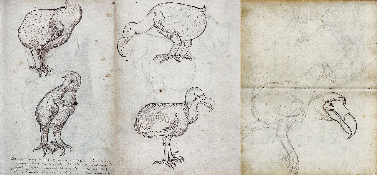
Two anonymous sketches (1601-1603) from the journal of the Dutch ship Gelderland under the command of Wolphart Harmanzoon.
Joris Carolus · Nationaal Archief, Den Haag, Archieven van de Compagnieën op Oost-Indië 1.04.01 inventorynumber 136

A drawing of a dead Red Rail or Red Hen of Mauritius (Aphanapteryx bonasia) with below a sketch of the head in graphite. An extinct rail species from Mauritius.
Joris Carolus · Nationaal Archief, Den Haag, Archieven van de Compagnieën op Oost-Indië 1.04.01 inventorynumber 136
Places
Named by the record
Places
Only places the record itself states, plotted where the house gazetteer settles their coordinates. Nothing is inferred from a name or a nationality.
Enkhuizen.
Birth place
Amsterdam.
Death place
Notes from the source article
Cited by Wikipedia
Notes from the source article
These works are cited by the source article, in its own numbering. They are recorded as its citations, not as sources VALÉORINE has verified.
- 1.Schilder, Günter. (2005). Mr. Joris Carolus (ca. 1566 - ca. 1636) 'Stierman ende caertschryver tot Enchuysen', in: Daalder, R.; Loomeijer, F.R. et al. (Ed.) (2005). Koersvast: vijf eeuwen navigatie op zee, Zaltbommel, The Netherlands. ; pp. 46–59 (Dutch)
- 2.Conway, Martin. Joris Carolus, Discoverer of Edge Island. The Geographical Journal. 17. 6. 623–632. 1901. 0016-7398.
- 3.Conway, Martin. Joris Carolus, Discoverer of Edge Island. The Geographical Journal. 17. 6. 623–632. 1901. 0016-7398.
- 4.Carolus, Joris. Geographicus Rare Antique Maps.
- 5.Holland, Clive. Arctic Exploration and Development, c. 500 B.C. to 1915: an encyclopedia. Garland. 1994.
- 6.Hart, S. De eerste Nederlandse tochten ter walvisvaart (1957), p. 50. Hart says it occurred in 1613.
References
Citations
References
Each reference names the institution holding it, so a reader may go to the document itself.
reference work
Secondary witnessreference work
Secondary witness
The Encyclopedia exists whether or not anything is for sale. Corrections are recorded rather than overwritten, and every version of this record is kept. Published 16 August 2026.
Elsewhere in Maps and atlases
1,180 published records in this field, each with its sources named.
- Jonathan CarverAuthor
- Joost Jansz. BilhamerAuthor
- Jorge ReinelAuthor
- Jørgen Henrich RawertAuthor
- Jos MurerAuthor
- José Antonio de Alzate y RamírezAuthor
- José de UrrutiaAuthor
- José Manuel de Moraleda y MonteroAuthor
Best supported in this field
For owners
Own a work by Joris Carolus?
A specialist will read what you send and tell you what the house can establish, what it cannot, and whether the object is suited to sale. There is no charge and no obligation. The object stays with you throughout; nothing is shipped to us unless it is arranged in writing beforehand.